Please note: We strongly recommend purchasing tickets online in advance to guarantee entry, as we do sell out on weekends.

BOSTON, MASS. (February 2020) – Understanding how changes in shipping traffic and distributions of fin, humpback, and blue whales in the Pacific Ocean affect the risk of whales being struck by ships is the focus of a new study published in the scientific journal, Frontiers. The findings also have implications for highly endangered North Atlantic right whales in the Atlantic Ocean.
Dr. Jessica V. Redfern, an Ecologist, Senior Scientist, and Chair of the new Spatial Ecology, Mapping, and Assessment Program (EcoMap) at the New England Aquarium’s Anderson Cabot Center for Ocean Life, is the lead author of the study. She maps the location of whale populations and uses these maps to assess the risks that whales face and is interested finding solutions to minimize these risks.
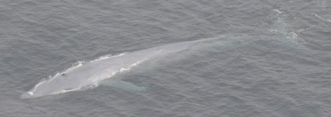
Off the West Coast, ship strikes are one of the biggest risks for fin, humpback, and blue whales. Unlike other studies that assess risk using a single year of ship traffic data, this study looked at multiple years of both ship traffic data and predicted fin, humpback, and blue whale distributions off California.
Among the findings, the location of shipping traffic determined risk. Since blue and humpback whales tend to occur nearshore, risk was higher for them when ships traveled close to the coast. Fin whales, however, tend to occur farther offshore so the risk was higher for them in most regions off California when ships travelled farther away from the coast. Redfern and her colleagues also found that the traffic pattern with the highest risk (i.e., ships traveling close to or far from the coast) was the same across all years of predicted whale distributions. The risk didn’t change because the whales were returning to the same feeding grounds.
“This result caught me by surprise,” said Redfern. “I was expecting to see more variability in the whale distributions. I found it really interesting that the locations with the highest predicted number of whales were the same among years.”
The consistency in risk is the key to finding management solutions. It means shipping lanes, speed limits, or no-go zones could help minimize risk as long as they are planned in relation to these areas with consistently higher numbers of whales. But, it is complicated by the fact that the risk from shipping traffic depends on each whale species’ distribution.
“My research is about identifying areas where we expect there to be lots of whales and planning our human activities in areas where there will be fewer whales. This planning ensures that we are using the ocean wisely and sustainably,” Redfern said. Her work began in La Jolla, California, at the National Oceanic and Atmospheric Administration’s Southwest Fisheries Science Center. There she developed models to map the spatial distribution of many ocean species, helping the U.S. Navy plan training exercises so that they minimized impacts on marine life.
On the East Coast, since the Gulf of Maine is warming faster than most of the world’s oceans, whale feeding patterns and distributions are changing. As water temperatures rise, some whales are moving farther north to find food. These changes could expose them to new risks, including increased ship strike risk. The locations of shipping lanes have been moved in the past to accommodate and protect endangered North Atlantic right whales as they migrate from Florida up to Canada. Redfern is excited about the tools she has developed to assess risks to marine species and looks forward to using them to solve conservation challenges on the East Coast.
LINK TO IMAGES OF FIN, HUMPBACK, AND BLUE WHALES FROM THE PACIFIC OCEAN:
MEDIA CONTACTS:
Pamela Bechtold Snyder, 617-973-5213; psnyder@neaq.org
Diana Brown McCloy, 978-697-9414; Diana@teakmedia.com
